You Should Know

46390 readers
42 users here now

YSK - for all the things that can make your life easier!

The rules for posting and commenting, besides the rules defined here for lemmy.world, are as follows:

Rules (interactive)


Rule 1- All posts must begin with YSK.

All posts must begin with YSK. If you're a Mastodon user, then include YSK after @youshouldknow. This is a community to share tips and tricks that will help you improve your life.


Rule 2- Your post body text must include the reason "Why" YSK:

**In your post's text body, you must include the reason "Why" YSK: It’s helpful for readability, and informs readers about the importance of the content. **


Rule 3- Do not seek mental, medical and professional help here.

Do not seek mental, medical and professional help here. Breaking this rule will not get you or your post removed, but it will put you at risk, and possibly in danger.


Rule 4- No self promotion or upvote-farming of any kind.

That's it.


Rule 5- No baiting or sealioning or promoting an agenda.

Posts and comments which, instead of being of an innocuous nature, are specifically intended (based on reports and in the opinion of our crack moderation team) to bait users into ideological wars on charged political topics will be removed and the authors warned - or banned - depending on severity.


Rule 6- Regarding non-YSK posts.

Provided it is about the community itself, you may post non-YSK posts using the [META] tag on your post title.


Rule 7- You can't harass or disturb other members.

If you harass or discriminate against any individual member, you will be removed.

If you are a member, sympathizer or a resemblant of a movement that is known to largely hate, mock, discriminate against, and/or want to take lives of a group of people and you were provably vocal about your hate, then you will be banned on sight.

For further explanation, clarification and feedback about this rule, you may follow this link.


Rule 8- All comments should try to stay relevant to their parent content.


Rule 9- Reposts from other platforms are not allowed.

Let everyone have their own content.


Rule 10- The majority of bots aren't allowed to participate here.

Unless included in our Whitelist for Bots, your bot will not be allowed to participate in this community. To have your bot whitelisted, please contact the moderators for a short review.


Rule 11- Posts must actually be true: Disiniformation, trolling, and being misleading will not be tolerated. Repeated or egregious attempts will earn you a ban. This also applies to filing reports: If you continually file false reports YOU WILL BE BANNED! We can see who reports what, and shenanigans will not be tolerated. We are not here to ban people who said something you don't like.

If you file a report, include what specific rule is being violated and how.


Partnered Communities:

You can view our partnered communities list by following this link. To partner with our community and be included, you are free to message the moderators or comment on a pinned post.

Community Moderation

For inquiry on becoming a moderator of this community, you may comment on the pinned post of the time, or simply shoot a message to the current moderators.

Credits

Our icon(masterpiece) was made by @clen15!

founded 3 years ago
MODERATORS
1


They're trying really hard to make their AI-plagiarized slop "news" site happen. You'll see posts linking to primestories24 [dot] com but they're AI slop regurgitating likely legit news articles. Every "reporter" has some generic profile that is most likely the system prompt used for everything they "write".

If you see a post to that domain, report it as spam. The accounts all look similar to this:

  • @Bellar36@beehaw.org
  • @Belinda42@lemmy.wtf
  • @tatyana43@piefed.ca
  • @Graham43@sopuli.xyz
  • @Belinda43@fedia.io
  • @belinda35@piefed.social
  • @PrimeStories247@lemmy.ca (First ban-evasion alt)
  • @PrimeStories24@sh.itjust.works (Original account)

This list isn't comprehensive.

Update: They are now using sockpuppet alts to vote/boost their posts. Just found @Babrah28@ttrpg.network that way and, surprise surprise, it was registered the same time as the latest batch.

Note: Technically the above is violating rule 7 if you consider spambots to be members. I don't, but if this is a problem, let me know, and I'll remove that part.

The domain was registered in May of 2026 and is roughly when these accounts started popping up.

   Domain Name: PRIMESTORIES24.COM
   Registry Domain ID: 3105727536_DOMAIN_COM-VRSN
   Registrar WHOIS Server: whois.web4africa.net
   Registrar URL: http://hostafrica.com/
   Updated Date: 2026-06-19T10:01:29Z
   Creation Date: 2026-05-31T12:16:00Z
   Registry Expiry Date: 2027-05-31T12:16:00Z
   Registrar: Host Africa (Pty.) Ltd.
   Registrar IANA ID: 664
   Registrar Abuse Contact Email: abuse@web4africa.net
   Registrar Abuse Contact Phone: +1.6465850088
   Domain Status: clientTransferProhibited https://icann.org/epp#clientTransferProhibited
   Name Server: DAN1.HOST-WW.NET
   Name Server: DAN2.HOST-WW.NET
   DNSSEC: unsigned

Admins, I'm aware Lemmy is severely lacking in moderation capability, but one thing it does have is domain blocking. That prevents posting to those domains and it now seems to prevent links to those domains from federating in.

2


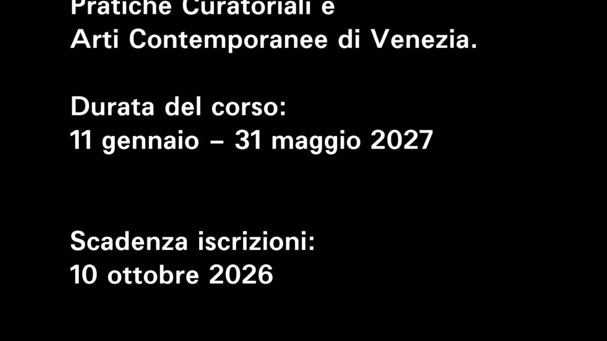
Aperte le iscrizioni alla 34° edizione del corso in pratiche curatoriali.

Il corso si svolge dal 11 gennaio al 31 maggio 2027 Termine iscrizioni 10 ottobre 2026

School for Curatorial Studies Venice è lieta di annunciare l’apertura delle iscrizioni alla 34°edizione del corso in pratiche curatoriali.

La scuola è stata fondata nel 2004 da Aurora Fonda e Sandro Pignotti con l’obiettivo di formare giovani professionisti culturali attraverso la diffusione dei saperi nell’ambito delle arti visive e la valorizzazione dei beni artistici e del territorio. Un corso di approfondimento sulle tendenze e i linguaggi dell’arte contemporanea connesso a conoscenze di scienze e storia sociale, filosofia, sociologia, semiotica, economia e imprenditoria.

Un progetto formativo altamente qualificato e indipendente in grado di offrire strumenti teorici e pratici al fine di operare con preparazione in istituzioni pubbliche e private associata alla professionalità di figure di rilievo nazionale ed internazionale per un progetto didattico altamente qualificato.

In questi anni di attività hanno partecipato più di 850 studenti provenienti da tutte le parti del mondo, che hanno avuto possibilità di confrontarsi con professionisti internazionali tra cui Matt Williams (Camden Arts Centre Londra) Louise Mckinney (a-i-r Londra) Chiara Barbieri (Peggy Guggenheim, Venezia) Chiara Bertola (Fond. Querini Stampalia, Venezia) Andrea Goffo (Fond Prada, Milano) Filippo Lotti (Sotheby’s Italy), i collezionisti: Alain Servais, Karsten Schmitz, Pedro Barbosa. Stefano Mudu, Elena Bongiorno, Saim Demircan, Grazine Subelyte (curatrice Peggy Guggenheim, Venezia), Stefano Mudu, Marta Papini. Un’occasione per introdurre gli studenti a professionisti con cui instaurare un solido e duraturo network professionale.

La conclusione di ogni corso vede gli studenti impegnati nella realizzazione di una mostra organizzata da loro, con il supporto logistico della scuola, in tutte le fasi organizzative: dall'ideazione, al contatto con gli artisti, all'allestimento, marketing, comunicazione e alla didattica. Ogni progetto espositivo viene accuratemente studiato, strutturando un'idea di mostra che ha sempre riscosso dei riscontri positivi da parte di artisti locali e internazionali.

Al termine del percorso viene rilasciato un attestato ed è prevista un’offerta di tirocini formativi con soggetti italiani e stranieri pensata per ogni singolo studente.

Ricordiamo che il corso è a numero chiuso e i posti sono limitati. È possibile iscriversi alla 34° edizione entro il 10 ottobre 2026. Durata del corso dal 11 gennaio al 31 maggio 2027.

Materie di studio: •Management e organizzazione •Ideazione e management di mostre d’arte ed eventi culturali. •Gestione degli eventi culturali •Analisi costi e benefici. Studio di fattibilità degli eventi artistici e culturali •Organizzazione e gestione delle risorse umane •Marketing e comunicazione •Relazioni istituzionali e fundraising •Collaborazioni con aziende private •Strategie di comunicazione locali, nazionali e internazionali •Pubbliche relazioni e promozione degli eventi d’arte •Storia delle Idee e delle pratiche artistiche •Storia dell’arte contemporanea •Analisi delle pratiche curatoriali dal ‘900 ad oggi •Elaborazione delle strategie curatoriali. •Incontri con artisti e visita dei loro studi. •Visite di mostre e fondazioni con professionisti del settore •Studio visit •Le problematiche legate agli allestimenti: il registar/assicurazioni/trasporti •Organizzazione e realizzazione progetto finale

Ricordiamo che il corso è a numero chiuso e i posti sono limitati.

Contatti: School of Curatorial Studies Venice T +39 041 2770466 info@corsocuratori.com curatorialschool@gmail.com www.corsocuratori.com

3


Some background context (assuming you're already roughly familiar with OpenStreetMap):

  • StreetComplete is an Android-exclusive app that acts as an extremely trimmed-down, gamified way to contribute to OpenStreetMap. You don't contribute new structures, but rather you fill in details about existing ones.
  • It'll ask you questions about existing structures like "How many levels does this building have?" or "What is the surface of this bike path?" These are called "quests", and it's expected (see: Bro Code, Division 6, Chapter 5, §32) that you're either there in person surveying or have been there recently and absolutely know that you're correct. The visual presentation is extremely smooth and beginner-friendly.
  • This is helpful not just to new users but to people who don't ever want to get deep into editing the map. (It can also help regular contributors notice small details they accidentally missed in an area.) A bunch of non-power-users contributing small details goes a long way to making the map actually robust and arguably better than services like GMaps – instead of just something that a few privacy/FOSS advocates vocally use and giant corporations silently use.
  • Go Map!! is a robust editor for iOS, kind of like an analog of Vespucci on Android.

However, I learned that Go Map!! isn't just a robust editor; you can also use it to contribute to StreetComplete's index of quests.

Why YSK: if you or a friend has an iOS device, this is a great way to contribute to OpenStreetMap with a very streamlined UI that acts more like a game than it does mapping software. I didn't know this before and would often only bring up StreetComplete and hope the other person has Android.

4


The report finds that data centers consumed about 4.4% of total U.S. electricity in 2023 and are expected to consume approximately 6.7 to 12% of total U.S. electricity by 2028. The report indicates that total data center electricity usage climbed from 58 TWh in 2014 to 176 TWh in 2023 and estimates an increase between 325 to 580 TWh by 2028.


I see a lot of people arguing about datacenters and their resource consumption. So i think it is good to have actual numbers on how much resources are being consumed. This post only includes energy consumption because i'm too lazy to look up water consumption.

5
 
 
6


Some accounts are deleting their posts after a few downvotes. It's devastating on communities like c/asklemmy.

Lemmy doesn't track an account's karma like reddit. So, all downvotes will be isolated to your post or comment and won't affect your account—unless you wrote something truly horrible.

Remember lemmy is a community effort. Deleting a post also removes all comments on it. So you are not only robbing the effort others put in, you are actively removing knowledge from the fediverse. Others won't be able to find it through search and lemmy will seem lonelier than it already is.

7


This summer, residents of Redmond, Bellevue, and Issaquah can apply to receive up to $2,000 off the purchase of a new e-bike.

https://www.redmond.gov/2537/E-Bike-Rebate-Program

https://bellevuewa.gov/city-government/departments/community-development/environmental-stewardship/transportation-electric-vehicles/pedal-forward-eastside

People from all 3 cities can apply from June 15 to June 29.

Recipients will be randomly selected.

To be notified when the application period opens, fill out this form

8


Im using it currently to recreate watching Adult Swim by shuffling all the shows opened with VLC.

But it can be done to simulate other syndicated tv channels just without commercials

Or breathe new life into an old series you've seen a million times in sequence

9


Awesome website. This is why the internet is amazing.

700 GB to torrent all.

https://charm.li/

10
11


cross-posted from: https://piefed.world/c/tech/p/1146502/telegram-apk-from-apkpure-is-a-spyware

On analyzing the APK with jadx, it contains a class DataCollector, which does not exist in the .apk file downloaded from the official Telegram website.

This class collects a lot of your data, including:

  • Your photos, videos, and files
  • Your contacts
  • Your messages
  • Your GPS Coordinates
  • Your SIM card information
  • Your Telegram profile

This data is monitored and uploaded continuously. All the data is uploaded to a server with IP Address 38.190.225.166

💬 Initial discovery by Eric Parker

🔗 APK Analysis: Part 1 | Part 2.

Source on Telegram.

12


web.archive.org (no paywall)

via

Every summer I repost this article on how to spot drowning. Please read it and pass on. In the last few years I’ve had SIX messages from people who saved a kid’s life after clicking on the link from my feed.

13
284
submitted 1 month ago* (last edited 1 month ago) by Wudi@feddit.uk to c/youshouldknow@lemmy.world


According to Harvard research, eating oranges stimulates growth of Faecalibacterium prausnitzia.

This bacteria lives inside the human gut and generates serotonin and dopamine — 2 powerful molecules that elevate your mood.

Harvard is one of the top 5 research universities in the world. Gary Ruvkun won the 2024 Nobel Prize in Medicine. Where does he work ? Harvard.

If you feel sad, eat an orange 🍊

14


Ysk about ageless linux to protest the age attestation that has passed in California. Ysk because the laws are unjust and discriminate against volunteer apps/OSs such as Linux distros.

15


Tiny11 builds a Windows 11 ISO that is 3.7GB in size, and installs in less than 10GB. It is so stripped down it doesn't even have a web browser, so it requires minimal updates, and runs great as a VM.

Personally, I use it for things like configuring Webcams or Controllers.

I recommend installing in KVM using a qcow2 disk image named Tiny11-Base.qcow2, then:

Install VirtIO tools

https://fedorapeople.org/groups/virt/virtio-win/direct-downloads/archive-virtio/

To get VirtIO on there you can use a USB stick, or use PowerShell as Administrator to download:

$url = "https://fedorapeople.org/groups/virt/virtio-win/direct-downloads/archive-virtio/virtio-win-0.1.285-1/virtio-win-guest-tools.exe"
$output = "c:\Users\User\Download\virtio.exe"

Import-Module BitsTransfer
Start-BitsTransfer -Source $url -Destination $output

Mount folders

This is so you don't need a browser or to use PowerShell for downloading. I mount my local Downloads folder.

Guide: https://www.debugpoint.com/kvm-share-folder-windows-guest/

Latest FSP (Fuse for Windows) at time of writing: https://github.com/winfsp/winfsp/releases/download/v2.2B1/winfsp-2.2.26112.msi

Snapshot and backup

Shutdown and create backups.

This retains sparse file compatibility (a disk that can grow as needed).

  • Snapshot will give you two files. Point your VM to the second one to use the snapshot.
  • The backup command will backup the original and the snapshot.

Snapshot

qemu-img create -f qcow2 -b Tiny11-Base.qcow2 -F qcow2 Tiny11-Active.qcow2

Backup

tar --use-compress-program=pbzip2 -cSvf Tiny11.tar.bz2 Tiny11*.qcow2

Export KVM

virsh dumpxml Tiny11 > Tiny11.xml 

Restore qcow2

tar --use-compress-program=pbzip2 -xvf ./Tiny11.tar.bz2

Import KVM

virsh define Tiny11.xml 
16


These are super disorganized thoughts. To clarify the title, I'm targeting people who may be interested in contributing to a project like OpenStreetMap but aren't interested in the narrow focus of things like roads, sidewalks, bike paths, houses, etc. I aim to capture some of the insane breadth and detail OpenStreetMap accommodates, but without just throwing you at the wiki and telling you to go nuts. That said, here's a list the wiki maintains of some map features. Note that these are standardized essentially by consensus/usage, so if you think something's missing, you can bring it up in forums like the wiki and try to gain consensus to formalize it into a standard.

TL;DR: We map everything*; if there's some infrastructure or natural formations you happen to have a special interest in, you can probably help. Obviously I think it's extremely important as a way of democratizing information and tearing down corporate hegemony, so understand that bias. The bias, too, is that OpenStreetMap in its ideal form is a fuckton better than something like Google Maps. If you ever progress to mapping as a hobby, you begin to realize how comparatively trash Google Maps actually is for very basic things like creating a walking route, accessibility, etc. It's not just that we can make it open – it's that we can do it better.

Keep in mind, too, that you can add as much or as little data as you want. If you want to map the species name of every tree, feel free; if you want to trace over a building and just call it a "building" with no other details, that's helpful too. So don't get intimidated; it's about what you can do, not what you can't.


  • Electrical – OpenStreetMap straight-up maps the global electrical grid. It's incomplete, but the tools are there, and there's a lot already done. By helping this, you're creating an open dataset in an area that's otherwise often extremely opaque. Your data may be the literal best open data that exists. There's a whole grassroots project dedicated to this called Map Your Grid. And here's a well-made tutorial using the powerful tool JOSM.
  • Micromapping – There are a metric fuckload of things that can be done here. You can map where garbage cans, drinking fountains, benches, street lamps, vending machines, photo booths, defibrillators, life rings near beaches, ATMs, fire hydrants, even manholes are. Benches as an example do show up on renderers like Carto (the one on the OSM website) and can be genuinely useful to individuals. Benches, waste/recycling bins, and drinking water are especially nice in public parks. They fill things out visually, but they're also really nice if you're thirsty or have an aluminum can burning a hole in your hand.
  • Directory – A huge reason Google Maps sees so much usage is a feedback loop where users expect to be able to find business information like hours, and business owners maintain that information. So you're fighting an uphill battle, and this is one of those fields where Google – by nature of having an army of business owners waiting hand and foot on their GMaps entries for free – is likely to remain dominant outside of, say, a small town. Nevertheless, a good-enough experience (or even a similarly premium one with a lot of coordination and legwork) helps dislodge Google's hegemony (and obviously, if you use it, to be useful to you).
    • Apps like StreetComplete are designed to streamline this specific kind of editing.
    • If you know people who manage businesses, let them know: they automatically have an edge in the niche OpenStreetMap arena just by taking five minutes every once in a blue moon to make sure their entry is up-to-date there. Especially when doing it alongside GMaps, you're adding nearly zero time and effort.
    • If you're adding timely information like opening hours, be sure to leave a check_date= parameter (on iD, this is "last checked date") saying when you last checked this information. This helps others decide how worth their while it is to re-check a business' information.
    • Edit: Okay, I guess this is "conventional", but to me, it's less "stereotypical".
  • Transit – this one's maybe too far into the "roads, sidewalks" etc. that some people aren't interested in, but I figured I'd mention it. You can create bus routes, add pretty specific information to airports (even down to e.g. holding positions), boat infrastructure like slipways, railroads and train stations, etc. You don't have to care about cars, bicycles, or walking to help improve transportation. (Although I would suggest bicycles are underrepresented on Google Maps and OpenStreetMap and that you can do a lot to help if you care about cycling infrastructure.)
  • Golf courses – Love them or hate them, there are a lot of fucking golf courses. For people who hate golf, mapping features presents data for environmental researchers. For people who love it, it presents a clean way to quickly visualize a course. (Open-air mini-golf works too, which can be nice if someone's wondering whether they should try out a course.) Either way, you can go into a decent level of detail, and it does look pretty on the map regardless of its ecological destruction. You can also add disc golf courses if that's more of your thing.
  • Fluviological – OpenStreetMap maps rivers, but we do a lot more than that. We map down the level of e.g. intermittent streams, ditches, culverts, etc. There are tools like topographic map layers that can help you with this in a more advanced way, but you know, if there's a small little insignificant creek that flows by your house, it'd still be really cool to have it on the map. You might be pleasantly surprised to follow it and see where it ends up.
  • Public bookcases – We do really map these. It's the "take a book, leave a book"-type. If there's one near you, put it on the map so people can find it – god knows when I've checked that Google Maps only captures a scant few of them. ("Micromapping" too, but this gets its own thing because I like it.)
  • Theme parks – Yes, we map these. Yes, you can go into a lot of detail, including tracing out roller coasters and water slides and adding individual attractions. You'd think these, being high-profile, would be picked clean of things to map, but that's really not always true, and it's surprisingly satisfying to just trace a waterslide. (To that end, local swimming pools are also ripe for mapping.)
  • Fences – Especially in sprawling suburbs, fences can give a more complete picture of the area, often giving a rough idea of where property lines are. Overall they just give things more definition, and since renderers like Carto show gates, it can help someone trying to find one.
  • Ballot drop-off boxes – Some municipalities will have boxes where you can drop off ballots, and we map these too. On a related note, library drop-off boxes are also tracked.
  • Building entrances – Entrances tell the map exactly where people can enter a building (and who's allowed), which can help for larger, more complex facilities like hospitals. With these, the router knows exactly where to walk you to for your destination.
  • Agriculture – In addition to drawing farmland, you can designate a specific crop. If you have one nearby and know what it's growing, feel free.
  • Public art – we track artwork like sculptures etc. We track names, artist names, materials, etc. The next time you see a (semi-permanent) public work of art (including murals), feel free to add it to the map. It's really nice to just stop and look sometimes.
  • Edit: A big one I forgot to mention on its own is accessibility metadata. Things like entrances, curbs, etc. can have this sort of information. For example, a curb can have the style of curb (flush/lowered/raised/rolled), tactile paving (y/n), and wheelchair accessibility.

A bit of philosophy: I think OpenStreetMap can be broken down in to four different sort of overlapping "fields", namely map, navigation, directory, and research data. These overlap heavily, but by my definition (to reemphasize: these are not entirely or even mostly distinct):

  • "Map" is the thing you actually see rendered (by some renderer) when you look at OpenStreetMap's data. It lets you look with your human eyes at an abstract representation of the world in a 2D plane (edit: or some renderers are 3D). What's especially useful if you care about this is to focus on the 2D polygons that make up areas. Is there a courtyard in a building not being shown? Make the building a multipolygon and add man_made=courtyard, so now it renders more accurately. Maybe neaten up the boundary of a nearby pond. For lines, you can do things like zoom in and better trace pathways and waterways, which can often be very rough approximations nobody ever fixed. Finally, for points, you can, as an example, do micromapping like benches that show up at higher zoom levels.
  • "Navigation" is concerned with getting between places. Obvious overlap with "map", but here I mainly mean routing algorithms. What's the best way to get between locations? What's the travel distance and time? Are there obstacles to look out for? Etc. You can especially help this by adding more detailed infrastructure like traffic signals, speed limits, etc. For micromobility, it's often especially helpful to find small things people missed, like a new footpath that acts as a shortcut for the router to take you through. Whatever you do, though, do not tag for the router! E.g. while we do map well-trodden "desire paths", don't put a crosswalk where there isn't one because you think it'll make your route 30 seconds faster.
  • "Directory" is concerned with essentially a business etc. directory – one where you can look at, say, a restaurant and say what its hours are, if it does delivery, what type of food it serves, if there's free Wi-Fi etc. You can help this by keeping information up-to-date if you see something is wrong or incomplete.
  • "Research data" is there to be a giant heap of structured data for e.g. research. Not looking at the map render, not individually reading entries for e.g. a nice park to go have a picnic at, but just throwing the raw values into an analysis. This obviously makes its way into all three of the other fields, but I keep it as a separate entity because of how much of it is outside those common applications. An example is infrastructure that people looking at a typical map, router, or directory won't care about like e.g. the electrical grid. Very few people are going to care that a power line runs in front of their friend's house or find that worthwhile to map over other options, but somebody trying to analyze the grid might very much care on a macroscopic level. The main thing to know about contributing for this specifically is that, while your edits can help locally, you're mainly playing a small part in a much larger game that needs all the help it can get.

I think that some people may find a strong affinity for one field over the others, which is why I delineate them here. Note that there are various pieces of editing software to do all of these depending on your use case.


* That's public information and relatively static. Don't be a creep, don't map the dog house that blew onto your lawn in a hurricane, and you'll be fine.


Anyway, this was just a smattering of different ideas.

Why YSK: Contributing to a project like OpenStreetMap really changes how you look at the physical environment, and I think it's for the better. It just makes you consider so many things you never would've, and I think it's a worthwhile experience. As someone who never played it, I can say that it scratches whatever draw Pokémon Go had to me but would've quite never fulfilled. Especially for the built environment, it gives you an excuse to explore new things.

17


18


Well known health influencer explains how to fight back health insurance denials in United States.

  • explains (in simyle terms) how insurance companies work.
  • shows basic steps to create a solid appeal.
  • recommends some online tools (AI based) to craft the appeals.
19


According to Rimu, the main developer of PieFed, all PieFed instances come with a 3000-long block list of resources that cannot be linked to. These include all sorts of right-wing outlets. There is no easy opt-out, forcing existing instances to follow the blocklist.

The flagship PieFed instance also rolled out a feature marking various other sorts of outlets - among them, resources considered AI slop and Marxist outlets. These are specific to piefed.social.

Related discussion: https://piefed.social/comment/11254679

Why YSK: Many users have hard time choosing between Lemmy, PieFed, and Kbin/Mbin. Users that prefer a more curated and politically uniform experience might prefer PieFed over the alternatives. Users that are right-wing, Marxist, or generally concerned about global censorship of the Fedi-/Threadiverse, might opt for other options instead.

Note: The post is only meant to inform users of the potentially important differences between Threadiverse platforms. Any ideologically charged discussions are better left in the respective topic.

20


Read the recent reviews since 2026-04-15. A reinstall of the extension fixed the performance issue.

21


De-prescribing refers to a structured, supervised process of stopping medications that are no longer necessary or beneficial. Ask your doctor the following questions:

  • What is this medication for? Do I still need it?

  • What would happen if I stopped it? Is there a safe way to stop?

Why you should know this

A supervised process of stopping medications that are no longer needed is something everyone should know about

22


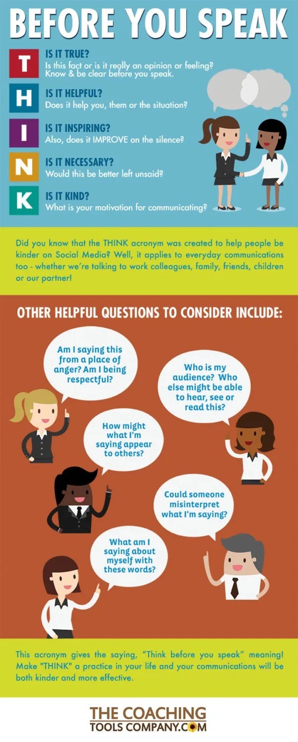
I really liked this graphic that I found here: https://www.thecoachingtoolscompany.com/think-acronym-for-kinder-and-more-effective-communications/

But it’s not the only source for the THINK acronym. This source claims it was created to reduce online bullying, but I believe the idea, and probably the acronym, have been around much longer than that.

Why YSK: we can all benefit from improving our communication skills, and this is one easy way to do that. I think a lot of us want to be kind, and this can help us better achieve that goal. It’s helped me a lot!

23


Why YSK:

Because this scenario:

I know what some people are thinking:

My eSIM is tied to my phone, phones these days have encryption, so all I need to do is set a lockscreen password then a thief cannot access any of my data.

WRONG

At least in Android: You can just use some button combo (just look up "[Phone model] hard reset") to get into the recovery menu and wipe all data, then reboot, and the eSIM is still there!

(Caveat to this: If you happen to have a Google account, it would force a FRP lock, and that would stop access, but most of fediverse does not like those type of online accounts, so: without a SIM PIN and without FRP locks, the eSIM is accessible to a thief)

Now the thief has your bank 2FA Codes!

TLDR: Set a pin on your SIM cards, even if it's an eSIM (but especially if you use physical SIM cards)

(Curious: Does anyone actually use SIM PINs or do I just have a lot of paranoid regarding tech and potential hacks/exploits)

24


You should know this because voter ID is one of the most debated topics in American politics, especially in recent years (SAVE America Act). On one hand, there's election integrity, and on the other, voter access.

cross-posted from: https://lemmy.world/post/46320788

Of these states, six have Democratic trifectas, 23 have Republican trifectas, and seven have divided governments. There are currently 14 states that do not require identification at the polls outside of what is required by federal law. Of these 14 states, 10 have Democratic trifectas, and four have a divided government.

25


PBS Passport is PBS's streaming service. You can a whole bunch of content for as low as $5 a month.

view more: next ›